|
The strange path of the storm, and what it may bode
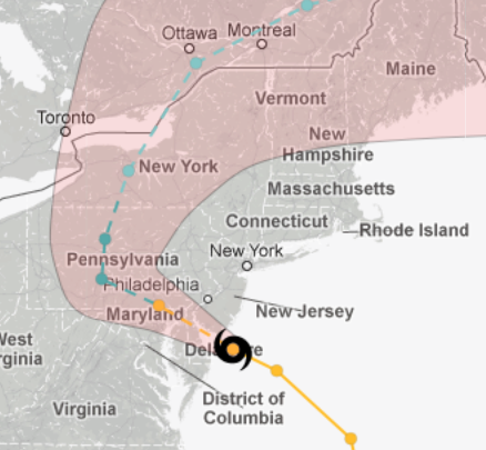
Here is a map of the hurricane’s path at the NYT website. The page, frustratingly, does not explain what the violet-colored area, as distinct from the surrounding grey area, means exactly, nor how much of this path is actual and how much is projected.
Does this mean that the Bible Code interpretation at the ever-sober and reliable World Net Daily, which says that the storm’s targetting of the Democratic Northeast but not the Republican South shows that it is God’s plan to elect Romney, is wrong? Not necessarily. Remember that New Jersey, New York, Connecticut, and Massachusetts are so overwhelmingly Democratic that there is no contest in those states, no matter how much the hurricane may lessen voter turnout there. However, the hurricane’s path is covering almost all of Pennsyvania, a state in which Obama is ahead but not by much. Suppressed voter turnout in Pennsylvania, especially among the “underprivileged,” could conceivably hand that state, and the election, to Romney.
D. Edwards writes: Take a look at this satellite loop of the weather systems. I think of it as “The meteorological battle for America.” One system from the left confronting the one from the right in the middle of America.LA replies:
But then the system on the right is coming from the leftist Northeast, and the system on the left is coming from the red heartland, sort of.D. Edwards replies:
The “traditional/natural” movements of weather systems is from the west to the east or northwest to the southeast (depending on the jet stream). The storm “Sandy” will be pushed back into the Atlantic by Sunday. I just thought that the satellite loop of this storm one week before the election was a funny joke from God. Two crashing forces meeting in the heartland of America.LA replies:
By the way, I haven’t once called the storm by its silly name. I just call it “the hurricane,” or “the storm.”Kristor writes: You write: Posted by Lawrence Auster at October 29, 2012 07:29 PM | Send Email entry |